Yosemite Winter Wonderland

Fresh snow at Yosemite National Park

An early storm in December brought snow to the mountain areas around California. For many years, I wanted to go to Yosemite National Park in the winter to take snow photos, but it never seemed to happen. This year, I went for it. The weather forecast showed a couple of clear days in between storms and with two days of lead time, I planned the trip.

Yosemite is about a four-hour drive, with most of the travel in the Central California region. The last 80 miles would climb to an elevation of about 4,000 feet at the floor of the Yosemite Valley. One of the members of my local photo club shared lots of useful information about visiting Yosemite in the winter, so I felt ready for the trip. I had not visited Yosemite for 17 years, so I was motivated to go.

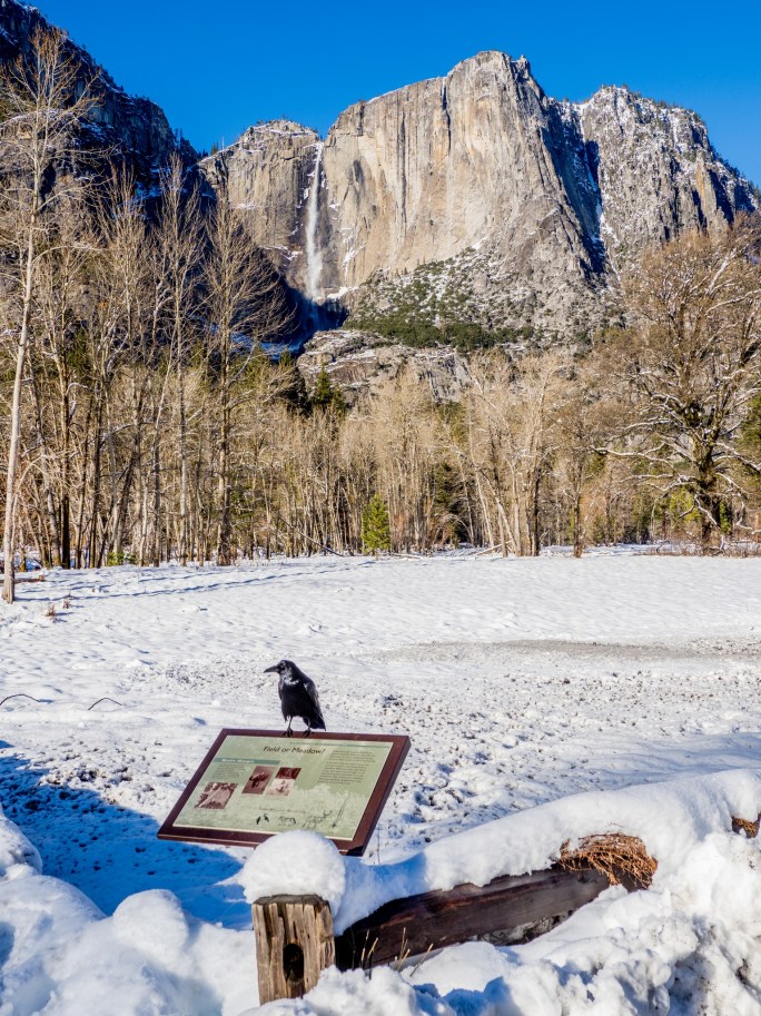
I left on Friday morning and arrived at the hotel around 1:00 p.m. The Yosemite View Lodge is in El Portal, CA, about 2 miles from the Yosemite Park entrance. After a quick check-in at the hotel, I drove into the park and entered a winter wonderland. The winter storm had cleared about 24 hours prior to my arrival, so plenty of fresh snow was still abound.

Tunnel View
The tunnel entrance at Tunnel View

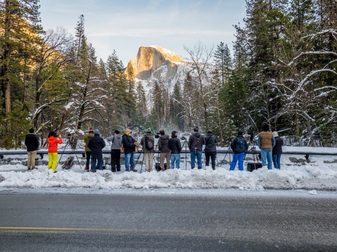
My first stop was Tunnel View, which provides a magnificent panoramic view of Yosemite Valley. It was also my first of many encounters with icy roads. When driving on ice, the general advice is to, “Slow Down!” I took that advice seriously and still noticed a considerable amount of sliding. (For the record, I was carrying chains, but did not install them.)

After leaving Tunnel View, I made my way back down to the valley floor and began navigating the various roads that meander around the area. I noticed the amount of road ice was significantly less at this slightly lower elevation. This made driving less nerve-wracking. However, walking on ice was still a hazard. The travel information from the photo club stressed the importance of wearing “ice gripping cables” on my hiking boots. I bought some just before leaving and they were a life-saver, in every sense of the word. I saw many people without these ice grips precariously trying to maintain their footing while careening across a frozen patch of ice on the ground. I wore mine full time, except when entering a building.

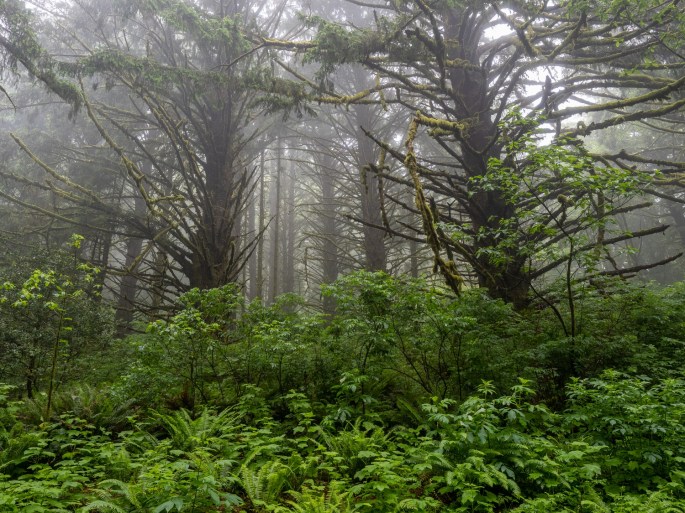
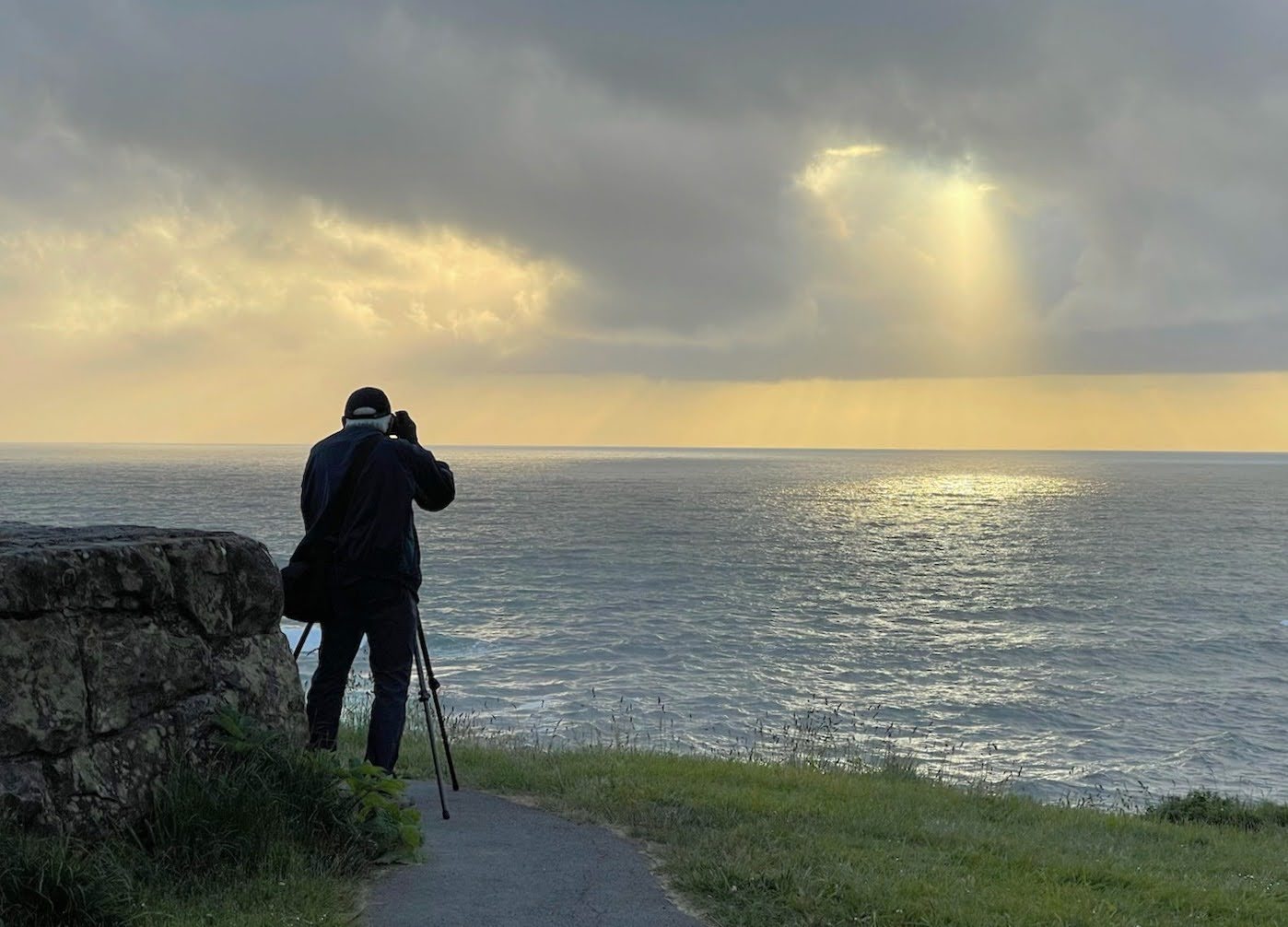
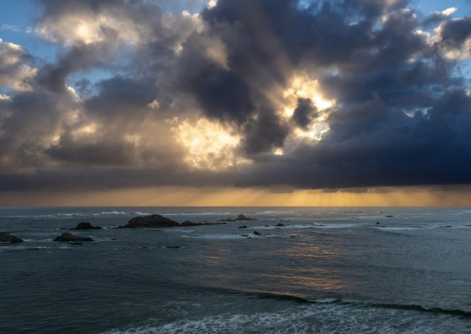
I spent the rest of Friday driving from spot to spot, taking photos of the beautiful and moody scenes around the park. I probably circumnavigated the main loop several times, each time finding a new perspective, or better lighting or just simply, another beautiful discovery. As dusk approached, a layer of ground fog moved in to provide yet another way to enjoy this place.

The view from Sentinel Bridge
The view of Sentinel Bridge

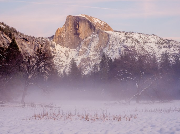
I ate dinner at the base food camp, a cafeteria-style restaurant in the park. After dinner, I planned to return to the hotel. Instead, I noticed a magical glow of light on the valley floor as a nearly full moon rose. Appreciating the numerous layers of warmth I was wearing, I enjoyed spending a little more time during this silent and dreamlike environment.

A full moon rises above the valley floor. Photo taken from Valley View location.

Fulfilled, I drove back to the hotel for a warm night’s rest.

On Saturday morning, I returned to the park for more photo adventures. It was obvious that more people were visiting the park that day. I was more confident driving on ice yet remained cautious. At one point, another vehicle was rounding a curve a little too fast and began to slide sideways into my lane. I was sure we would collide and braced myself for the impact. I steered slightly to the right until I could feel my car rubbing along the snowbank. For some inexplicable reason, the driver of the other car regained traction and narrowly drove past me without contact. The entire incident happened in less than 3 seconds and then was over. Over, except for my racing heartrate and my clear verbal displeasure with what had just happened.

A little while later, I passed a damaged truck that had apparently struck a tree and spun around.

These were two additional reminders to take my time and keep my speed down.

Early morning at Valley View

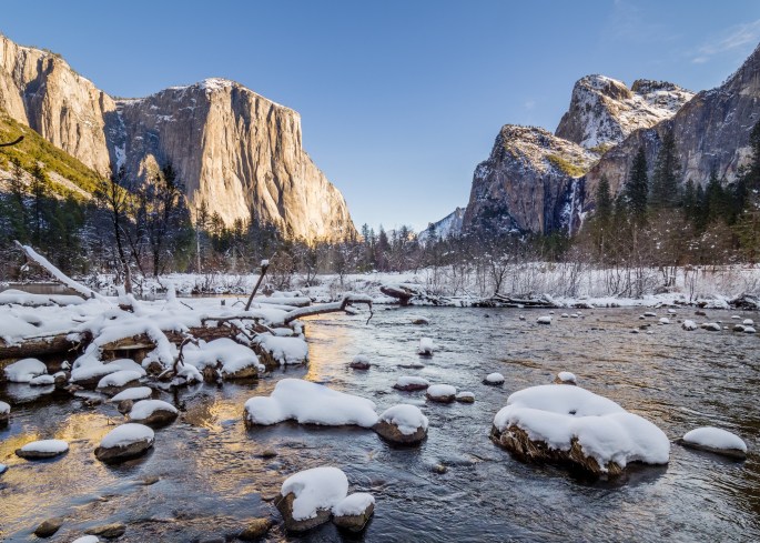
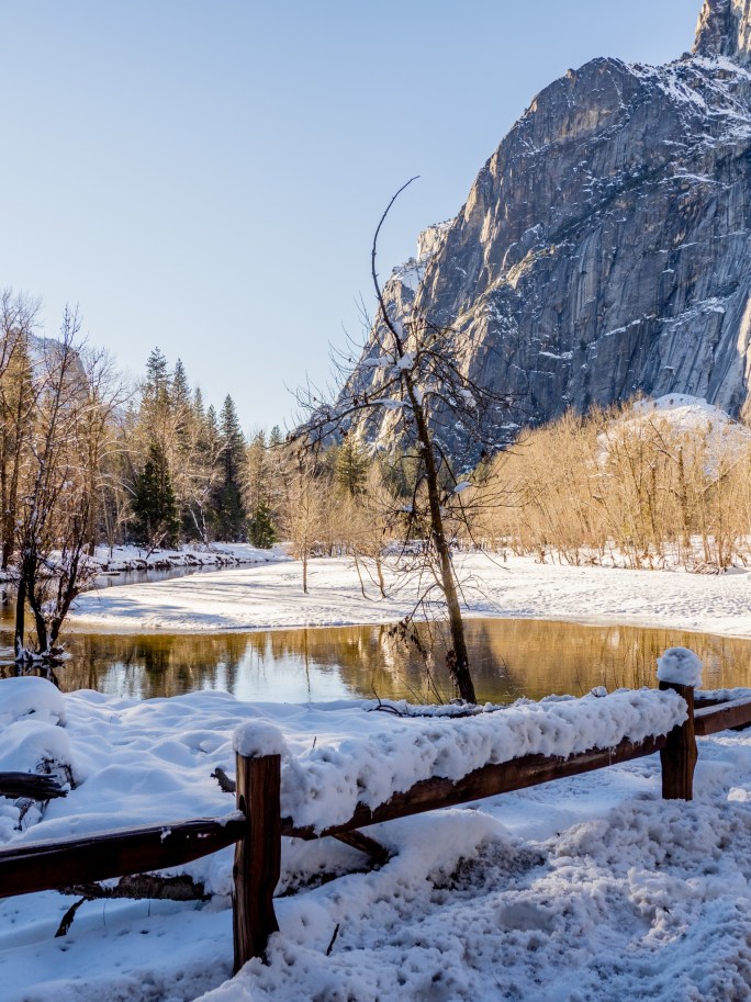
During this day, I ventured farther from the roads and walked out into the open spaces for better vantage points. The ice grips on my shoes worked great on the packed snow. I hiked toward the Merced River at one point to get a better view of the river and Half Dome. This location turned out to be a jewel, with no one else within sight or earshot. Quite a feat during a busy Saturday!

Half Dome and Merced River
Silence along the Merced River
Bridalveil Falls

I leisurely hiked and made photos throughout the day. Several times, I realized I was taking photos from the same viewpoints I used on Friday. With later comparisons, the photos were still different enough to appreciate the differences in lighting, timing and color tones.

Upper and Lower Yosemite Falls

After Saturday dinner at the cafeteria, I returned to the hotel and spent the rest of the evening viewing and editing the photos I had taken. I realized I had captured the beauty I experienced and decided not to re-enter the park on Sunday. It was check-out day at the hotel anyway, so I packed and began the journey home.

Now, more storms are stacking up, so I expect Yosemite to receive much more snow over the next few weeks. I’m sure I’ll have another chance to visit again during a fair-weather window; I’m sure I’ll make the trip.

– + –

Pacific Northwest Photo Slideshow

I assembled a photo slideshow of photos I took while on my road trip in the Pacific Northwest in May and June of this year. The video is about 5 minutes long and the musical soundtrack is the Cat Stevens song, “On the Road to Find Out.”

For the best enjoyment, click on the “Watch on YouTube” link below and choose to watch it in full frame mode.

– + –

Photo Journal – Smith Rock State Park

Tuesday (June 22): The Smith Rock State Park is located about 20 miles from Prineville. The park reopened less than a month ago after being closed for more than a year due to Covid.

Smith Rock State Park
The Crooked River winds through the park

I spent a couple hours at Smith Rock hiking the trails this morning. After last night’s thunderstorm and balmy night, it felt good to walk in the cooler air. Not only was the air cool, it was absolutely still. Occasionally, I would stop hiking to take a photo and notice the silence. It was so quiet that I felt conspicuous when I restarted hiking because my shoes were making noise.

Smith Rock State Park

This area has stunning rock spires that stretch vertically from the canyon floor. The Crooked River wiggles through the spaces between the rock faces. In the 80’s this park was a huge draw for rock climbers. Now, in addition to the continued focus on rock climbing, miles of trails beckon hikers and bikers to explore the area. I hiked trails in both directions along the river’s path.

Smith Rock State Park
Rock climbing class
Smith Rock State Park

After returning to my starting point, I got the notion to take the Misery Ridge Trail. Somebody had a sense of humor when they named this trail. It immediately transitions into switchbacks as the hiker climbs from the trailhead at the bridge.

Smith Rock State Park
The Misery Ridge Trail
Smith Rock State Park
The Misery Ridge Trail. I hiked up as far the upper right area where the trail wraps around the rock
Smith Rock State Park
Looking down from the upper part of the Misery Ridge Trail

I climbed about half the vertical height of this trail before stopping. I was rather proud of myself for not being intimidated by the sheer height of the trail, as well as its close proximity to the steep edge. When I began to hike back down, all that changed. When hiking down it was hard to not see the height and precariousness of the trail.

Don’t miss this right turn!

By the time I reached the bottom I was pretty tired. I still needed to cross the bridge and climb out of the canyon one more time. Slow and steady was my mantra (when I could breathe). The cool air had warmed up by late morning, and the humidity seemed to have increased, too.

Smith Rock State Park

I drove into nearby Redmond and met up with a former co-worker/current friend for lunch. Jerry and I share a strong interest in photography and we often send emails back and forth discussing the latest photo gear and techniques. He had recommended I visit Smith Rock SP and gave me good advice to get there early before it got too busy.

We had a terrific lunch of tacos from a food truck parked at a taphouse. It was fun to catch up with him and he had more suggestions of places to check out in the area.

I spent the remainder of the afternoon buying groceries and supplies for the last week (sniff, sniff) of my trip. When I was leaving Safeway in Redmond, the lightning and thunder had started. I drove back to Prineville and outran the storm by a couple hours. When the storm did arrive, it was not nearly as powerful as the previous night’s fracas. In addition to another stunning sunset, I was treated to a full rainbow at the RV park. One end of the rainbow burrowed into the roof of my trailer. I think I should name my trailer “Pot of Gold.”

A rainbow send-off

Tomorrow is the first of another two-day travel leg. When I stop for the night tomorrow, I’ll be back in California.

– + –

Photo Journal – Multnomah Falls

Sunday (June 20): Happy Father’s Day! This was a rare time that I wasn’t available to see my sons on Father’s Day. We had good phone chats instead.

I did manage to wake up with the alarm and hit the road early to visit Multnomah Falls. It’s about a 45 minute drive and I remembered seeing a sign on the highway about the parking lot exits being closed after 9:00 AM on the weekends. I arrived at the parking lot just before 8:00, so I made good time. Other people were milling about, but it wasn’t crowded.

Multnomah Falls
In the early morning (8:00 am) the entire falls are in the shade.

Multnomah Falls are located very close to the highway. The parking lot is opposite the railroad tracks and an under-the-tracks tunnel connects to the waterfall area. The lower viewing platform gives a stunning view of the long ribbon of water as it falls more than 500 feet, and continues another 60+ feet to a collection pool at the bottom. It is pretty dramatic and the photos do not do it justice.

Multnomah Falls
The lower falls and Benson Bridge.
Lower falls detail

It was fun to people-watch on the lower platform. Lots of selfie sticks (and selfie arms). I would frequently offer to take photos of a couple or a family so they could all be in the picture together.

The lower viewing platform offers an excellent introduction to Multnomah Falls

The hike up to the observation bridge, known as Benson Bridge, is a short climb with a few switchbacks. This location offers a great view of the landing area of the upper falls. I was enamored with the soft spray of falling water juxtaposed with the large moss-covered boulders and rock walls.

Multnomah Falls
Looking down from Benson Bridge at the viewing platform.
Multnomah Falls
The upper falls
Multnomah Falls
Upper falls detail
Multnomah Falls
Upper falls detail

A trail continues up to the top of the upper falls, but I chose to spend my time near the landing areas. I took 252 photos of the falls. Many of them were multiple clicks of the same image, with the randomness of the falling water patterns making the difference.

Multnomah Falls
This trail leads to the top of the upper falls.
Multnomah Falls
Upper falls detail
Multnomah Falls
Benson Bridge
Columbia River Gorge, looking east
Columbia River Gorge, looking west

By about 10:00 AM I was ready to leave. The crowds had arrived and the sunlight was beginning to infiltrate the softly lit area of the falls.

I’m very happy I made the drive to visit Multnomah Falls. This is a location I’ve been wanting to see for many years.

Tomorrow is a travel day as I move south into Central Oregon. I’ll be staying at Prineville, Oregon which is in the Redmond and Bend area.

– + –

Photo Journal – The Two Hood Rivers

Saturday (June 19): I trekked out late yesterday evening and walked along The Hood River as it flows alongside this campground. I waited until dusk for better light for photos. The mosquitos were abundant, but they were not interested in my blood. I’m lucky like that. Maybe I should sell my blood as a mosquito repellent.

Hood River
The Hood River directly behind my campsite

The river runs strong here and it has a powerful sound. I spent a little more than an hour trailblazing my way along the shoreline. I found a few sideline areas that probably have river flow when the water level is higher. All of these photos were taken within the boundaries of the campground.

Hood River
The Hood River makes an impressive sound.
Sometimes the water can be abstract.
This is probably part of the river’s flow when the water levels are higher
Next to my campsite
Directly behind my trailer

Today I ventured back down to Hood River. I ran a couple of errands and drove randomly in the upper hills of the city trying to find a good vantage point to get photos of the Columbia River Gorge area.

Downtown Hood River. It looks quiet because I waited for a line of cars to move along before I took the photo.
I would call this the “Paint Sample House.”
From the upper hills of Hood River, looking north at the Columbia River Gorge. Mt Adams is in the distance.
The water recreation area of the Columbia River Gorge

I drove down to the waterfront and directly parked in a free 3-hour parking space. Lucky again! A short walk brought me to the shoreline of the Columbia River. I was not alone. This area is a high adventure spot. The consistent strong winds and large water area combine for a great kiteboarding and windsurfing destination. And it was busy.

Spectators get to enjoy the wind, too!
The launching/landing beach.

I would estimate the wind was blowing a steady 40 mph with gusts up to 50. Apparently, this is ideal weather for this sport, as the river area was a visual cacophony of movements of people, zig zagging across the water. There must be an etiquette to maneuvering in this crowd because there were no collisions and I never saw anyone’s kite ropes get tangled with another’s.

How do all these people not run into each other?

On a few occasions, a surfer would become separated from their board. Another surfer would skim along, grab the vacant board, make a quick turn and drop it off with its owner. It was fun to watch (and photograph) all the action. After a while I was able to predict when a surfer would be preparing to execute an airborne maneuver or make a sharp turn.

Mad skills
Getting some air!
The guy looks like he realized he lost his hat.

All of this energy and chaos made me hungry. I drove back into town and got on the waiting list at the Full Sail Brewpub. After a 45-minute wait, I was seated at a window overlooking the Gorge. The amber ale was fresh and the burger was tasty.

The view from my lunch table.
Mt. Hood, as I drive back to my campground.
Mt Adams, to the north.

Tomorrow I plan to explore some of the outlying areas, including taking my chances at visiting Multnomah Falls. I will need to get up early in order to do that. Wish me luck.

– + –

Exploring Cannon Beach, Astoria and Cape Disappointment

Thursday (June 17):
My visit to this Washington peninsula would offer only two full days to explore the area. I knew the time would go quickly so I wanted to prioritize my choices. In addition to checking out this area, I also wanted to go back to Cannon Beach and spend a couple of hours there.

My visit to Cannon Beach was timed perfectly for the weather. After a rainy morning on Tuesday, the weather cleared by mid-day. Cannon Beach is a popular destination, with a vibrant downtown corridor and adjoining beach. Haystack Rock stands prominently as the centerpiece of the long flat beach. Parking in the area is competitive; I was fortunate to grab a roadside space near an entrance to the beach.

Haystack Rock on Cannon Beach
Looking south
Haystack Rock on Cannon Beach
Low tide
Puffins! This is a composite of four images of puffins in flight.
Haystack Rock on Cannon Beach
Beach reflections

On the way back from Cannon Beach, I turned off to visit Fort Stevens State Park on the Oregon side of the Columbia River. Many of the river viewpoints were closed due to jetty construction. I was able to check out the shipwreck on the beach.

Shipwreck at Fort Stevens

With the beautiful blue sky, I stopped in Astoria to get some new photos of the Astoria bridge. I returned to the same vantage point I took photos from the previous day. It’s a narrow residential street in the hills above the river with an excellent view of the entire bridge. I had to squeeze my car into a small turnoff space and walk a few blocks back to the best shooting spot. I was careful to not disrupt the homeowners on this street, I’m sure they see plenty of tourists checking out the view. I also drove down to the waterfront and walked along the area on either side of the bridge.

Astoria Oregon
Wide view of Astoria Bridge
View from the waterfront

On my last afternoon, I went to the Astoria Brewing Company located on the waterfront overlooking the river. Naturally I ordered fish and chips and a cup of chowder. The chowder was excellent but I’m not considering it as a candidate for my “best chowder” search. They add bacon to their chowder, which tastes great, but I call that cheating. I enjoyed eating the chowder, even though I had disqualified it. The halibut fish and chips were very good and I paired it with a very smooth blonde ale. I left the restaurant very satisfied with my last supper of the area.

Last supper at Astoria Brewing Co

Cape Disappointment State Park includes more than the campground. This area reflects the history of the Lewis and Clark Expedition; the expedition reached the Pacific Ocean here at the mouth of the Columbia River. The park includes a Lewis and Clark interpretive center, two lighthouses and several historical remnants from the Pacific coast defense during World War II.

One of the lighthouses overlooks the beach next to my campsite; it is called the North Head Lighthouse. The park offers easy access to this lighthouse; a good sized parking lot and paved trail makes for an easy visit. This spot also has a trail to another viewpoint (called Bells Lookout) which gives hikers a chance to visit an old WWII bunker.

North Head Lighthouse above the campground beach
North Head Lighthouse
WWII Bunker
WWII Bunker
WWII Bunker
Three levels
WWII Bunker
Ocean view
North Head Lighthouse
This is the campground beach, looking back from the North Head Lighthouse

The other lighthouse is called Cape Disappointment Lighthouse and can be viewed from the Lewis and Clark interpretive center. This interpretive center is also home to the rugged structures of Fort Canby. While at the center I noticed a jetty that looked like it would have a great view of the lighthouse at water level. I consulted a map to see if I might be able to reach this spot and learned it is located in my campground. Very convenient and an excellent viewpoint of the lighthouse!

Cape Disappointment Lighthouse, viewed from the Lewis and Clark Interpretive Center
Fort Canby at the Lewis and Clark Interpretive Center
Fort Canby Exterior
Fort Canby Exterior
Fort Canby Exterior
Cape Disappointment Lighthouse
Cape Disappointment Lighthouse, viewed from the campground jetty

On the second evening of taking sunset photos of the Cape Disappointment Lighthouse, it drizzled for a few minutes. About 15 minutes later, a beautiful rainbow arced across the sky, directly over the lighthouse point. I was gifted with about 10 minutes of viewing (and photographing) this spontaneous gift.

Cape Disappointment Lighthouse
Cape Disappointment Lighthouse at sunset
Cape Disappointment Lighthouse
Rainbow!
Nightfall at the Cape Disappointment Lighthouse

Before settling down for the last night, I visited the campground beach for one last walk. The wind was blowing fiercely but the walk in the water’s edge was pleasant and bittersweet.

Last walk on a beach

My time spent on the beaches over the last three weeks has been very rewarding. I’ve felt a special sense of peace while walking in the water, outrunning the seagulls in search of intact sand dollars, inspecting the little shells in the sand and watching the rhythmic rolling of the waves. This experience has been cleansing, calming and rejuvenating. I will miss the beaches I’ve visited.

Last walk on a beach

This is a turning point of my road trip. My next two travel days will take me inland toward Hood River on the Columbia River Gorge. In a way, I’ll have two trips: the coastline tour and the central Oregon route. As I say “Good Bye” to the ocean, I look forward to the new adventures that await me.

– + –

Travel Day – Barview Jetty to Cape Disappointment

Monday (June 14): After 36 hours of soaking rain, Monday morning was dry(er); this made packing and closing up the trailer much easier. While breaking camp, I chatted with the gentleman in the next space. He was curious about the a-frame trailer and shared plenty of stories of his truck-driving days. We said our good-byes and I pulled away for another mini-trek to my next destination: Cape Disappointment State Park in Washington.

Traffic along the coastline was heavier than I expected, and the traffic progress was complicated by heavy fog in several places. I had hoped to stop at Cannon Beach for a lunch break, but decided in advance to continue onward if the fog had claimed Cannon Beach for the day. As it turned out, Cannon Beach was fogged in and I kept driving north. I did pull over for one foggy opportunity – I noticed some dense wooded areas off the highway with some excellent-looking fog in the treetops. I found a reasonable turnout and spent about 20 minutes walking up a dirt road through the foggy trees. It was a nice break.

A walk in the fog

Some of the other cities looked pretty interesting and I considered making a day trip to this area from the campground in Washington. I was mostly curious about Astoria, the last Oregon city I would drive through before crossing the Columbia River to Washington.

Before I had a chance to take a look at Astoria, an ominous sight appeared ahead of me. It was what I would call, “The Mother of All Bridges.” I had heard the bridge over the Columbia River was pretty high and long, but I did not expect it to taunt drivers from several miles away.

The Mother of All Bridges – The Astoria Megler Bridge.
White-knuckling across the bridge

The route onto the bridge was very direct with no last-minute escape routes. I was committed to driving over it so I took a deep breath (maybe more than one) and pushed forward. Let’s just say it was breath-taking. I thought I was doing pretty well until I noticed my hands getting very tired from squeezing the steering wheel. I remembered the good golf advice about relaxing my grip, but this was no simple case of putting a golf ball. I was driving my car and trailer over a skinny, metal, two-lane, 4-mile long bridge that was tall enough for the largest ships to pass under. And it was windy. And I had to pee.

Once I crested the highest point of the bridge, the downhill slope was very stimulating. I could see contiguous highway ahead all the way to the Washington shoreline, but it was questionable how cars managed to stay on that thread-like strip of asphalt.

On the downhill side

Naturally, it was no big deal. Thousands of cars traverse that span every day and none of them spontaneously jump over the edge. I just wanted to be sure mine wouldn’t be the first one.

Cape Disappointment State Park is about 12 miles from the bridge and the Washington shoreline is beautiful. I entered the campground and set up camp, all the while noticing the clear and close sound of the ocean. I learned I was camping about 50 yards from the path that leads to the beach. So I checked it out.

Cape Disappointment State Park

It’s another long beach, in fact, a nearby community is called Long Beach. I opted to take a short walk, and was pleasantly surprised to notice a lighthouse clearly visible and the north end of the beach. I did not know how this place became known as Cape Disappointment, but I was not disappointed.

This beach is very close to my campsite.

I returned to my trailer and set it up for my three night stay. This part of the campground is dry-camping with no electrical connection. I will be watching my battery power level and looking for chances to replenish it with the solar system. I’ll just need some sunlight, that’s all. Shouldn’t be a problem.

One note – the cellular signal in this park is very weak, so my updates during this time may be limited and delayed until I reach a better location.

– + –

LWOTB (Long Walks on the Beach)

South Beach
8:30 AM – First look at South Beach

Wednesday (June 9): I slept solid after all the excitement on Tuesday. The bright sun and blue sky tempted me, so I dressed quickly and walked 1/4 mile to South Beach. The crisp air was refreshing and I walked barefoot in the shallow surf. The water was stunningly cold but after awhile my feet were so numb I didn’t notice. A few others were also out on the beach on that morning. As I walked along, I began searching for sand dollars that washed up on the shore. Most of the ones I saw were partial pieces and any round ones had been chipped open by the seagulls.

S
A long walk on a beach requires a long beach.
Looking for a wave

After about 45 minutes of intense searching, I had found 4 undamaged sand dollars. I was rich! I looked up and noticed how far I had walked. Actually, I had no idea how far I walked because I couldn’t see where I started. I wandered back and eventually located my starting point and walked back to my campsite. I made coffee and breakfast and started planning my day.

My beach bounty

A former coworker had contacted me a couple days earlier; he and his fiance were staying at a nearby Thousand Trails campground during the same time I would be in Newport. I reached out to him and arranged to stop by their campground for a visit. I met his fiance and another friend, took a walking tour of the campground and checked out the beach nearest to them. I wondered if I had kept walking that morning if I would have ended up at their beach. I estimated it to be about four miles away.

We agreed to meet for dinner on Friday afternoon and I left to run some errands. I needed to get a few supplies to finish my trailer cleanout from the previous day. When I returned to my campsite in the afternoon, I took an unplanned two-hour nap. I guess I was tired.

After an early dinner, I headed back to the beach for a sunset LWOTB. I found a few other shells and took photos of the sunset and beach objects I came across.

Sunset walk on the beach

My Steps app let me know I had accomplished my steps goal for the day!

No wonder my butt muscles hurt,

– + –

Photo Journal – Last look at Sunset Bay and Cape Arago State Parks

Tuesday (June 8): Yesterday was my last full day in this area. Here are a few last looks at this beautiful part of Oregon.

Ferns in woods
Exposed roots
Exposed roots
Cape Arago coastline
Simpson Reef rocks
Simpson Reef rocks
Cape Arago south view
Cape Arago coastline
Wave
Catch a wave and you’re sitting on top of the world
Cape Arago Lighthouse
Cape Arago evening
Cape Arago evening
Cape Arago at Dusk
Cape Arago at Dusk
Sunset Bay Beach
Sunset Bay Beach
Sunset Bay SP Waves
Sunset Bay SP Waves
Sunset Bay State Park Dusk
Photo by Zack Schnepf Zack took this shot of me while I was chasing the light.
Simpson Reef Sunset
Simpson Reef Sunset

Today I’ll pack up and drive north about two hours to Newport. I’ll remember this visit for a long time and I have many photos to help keep those memories alive!

– + –